COASTAL PATHS PROJECT (GALICIA-ASTURIAS)
seawall was always a calm and promoting activity of the relaxation, stimulating our senses through sounds, aromas, light, images ... Visiting
cut profiles of the coast, mixed with the waves between beaches, cliffs and seascapes, it is an unforgettable treat for any traveler who wants to know these areas.
In most cases, the so-called "coastal paths," Inland routes are often little closer to shore, and are not very showy and dull to reason through forests of eucalyptus and pine trees and stepping much asphalt.
Thus, from the Hiking Club Acivro, echoing numerous requests to that, we start an interesting scheme called "Project Coastal Paths", ie allowing to meet beautiful coastal areas in a series of "real "shore excursions specially chosen and selected for their beauty .
In this ambitious project, we will over time thirteen beautiful trips a day, specially chosen for the occasion in which we can see from typical fishing villages to beautiful beaches, dramatic cliffs and beautiful coastal scenery.
excursions included in the project are: *
Road Ares-Mugardos Coast (Costa Ártabra-Ferrol)
* Route Tapia de Casariego-Castropol (Asturias)
* Route Viavélez-Tapia de Casariego (Asturias )
* Naviego Coast Trail (Asturias)
* Route Ortiguera-Viavélez (Asturias)
* Route da Costa Doce (Sada, A Coruña)
* Path of Cabo de Peñas (Asturias)
* Route Cedeira-San Andres Teixido (Ferrol)
* Route Algae (Ortigueira-A Coruña) * Route
Arnao-San Juan de la Arena (Trail North-Asturias)
* National Park of the Atlantic Islands of Galicia (Islas Cies)
* National Park of the Atlantic Islands of Galicia (Isla de Ons)
* National Park Atlantic Islands of Galicia (Cortegada Island)
Each tour built into the project will bear the below, along with the words "Coastal Trails Project," and they will be suitable for all kinds of people with minimal shape, having always a degree of difficulty to "easy" or "medium" for the lack of roads to save. 
As always, seats are limited to 36 people to enjoy the activity as possible so you can walk quietly, to escape the overcrowding.
Greetings to all and invite you to visit these lovely paths together in this interesting project called "Project Coastal Paths." Hiking Club Acivro
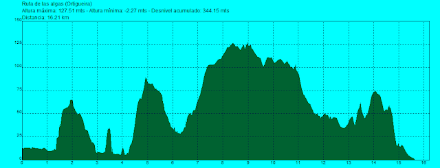
ROUTE 26 MARCH 2011 OF ALGAE (ORTIGUEIRA)
(DRAFT COASTAL PATHS)
Distance: 15.5 km route
Duration: 5 hours
Difficulty: Easy
Route description: Route
algae is a most beautiful coastal routes and existing attractions in the Autonomous Community of Galicia, with many important natural and scenic values \u200b\u200bthat make this journey is truly an unforgettable experience for any traveler, allowing to discover the great attractions housed in the town of Ortigueira.
This route is a collection of routes that run along the edge Ortigueira coast, by the so-called "Camino de la Costa" They are as follows: Road
intertidal bark (not included in the route by low interest)
sailors Route Route Espasante
Celtigos cliffs
Furada Route de la Pena (Celtigos)
Route algae (Loiba)
The starting point of this beautiful map is the town of Espasante, very quiet and away from tourist overcrowding elsewhere.
Then we reach the beautiful beach of La Concha, very wide and fine sand, from which we can see how far in front and the town of Honey and even Cape Ortegal, with three needles and impressive lighthouse. We walk along the beach along the attractive promenade and headed to the auction, leading to the bay of Santa Cristina, well hidden and that goes unnoticed.
From here we climb to a vantage point where it was totally hidden, the fascinating site of Punta dos Prados, which holds the remains of a small fortified village built in the IV century BC, famous for having the best preserved monument forno Galicia. The various authors agree that identifying this site as a public beach without mentioning the funerary ritual or attributed to other buildings of this type. This construction is unique in architecture exhumed since its semicircular difference of all known in Galicia and Portugal-square-rectangular.
After visiting the site, we ascend the slope on a path to reach the checkpoint da Vela, construction monitoring of the eighteenth century, from which to contemplate unsurpassable views of the coast Ártabra with Honey, Cape Ortegal, the majority of Ortigueira and Bark, Espasante village with its beach, and Away the coastline we're going to go.
descended to the town road to access the beautiful beach of San Antón, fine sand, which traverse the entire length. The beach offers views of cliffs, boulders and rocks near the sea usually enbravecido. Finally
the beach we went for a somewhat difficult path that climbs over the hill, crossed and we can access the beach Eirón, virtually untouched and very beautiful. Your access is difficult with the help of a rope through the difficulty and poor condition of the trail.
Again Eirón cross the beach, enjoying every moment on these beaches almost untouched, until another beach, Playa de Bimbieiro or Mazorgán.
From here, following the coastline, we arrive at a grassland area from which the left see the beautiful beach of Ribeira dos Ourizos small, rocky and inaccessible. Somewhat later
offers a unique and difficult to forget one of the largest beaches in the municipality of Ortigueira: the Ribeira Grande or Sarridal, beautiful and safe as other mass tourism of the coastal area are not accessible or precarious access.
After enjoying the view, continue to the village of Wall, where we get into the interior by roads that pass near eucalyptus and pine forests. We
near the site of Rubido and neared the coast, past the difficult access to the beach Sarridal.
A little later, we reached a point where we turn to the viewpoint of Furada Pena, impressive rock emerging from the sea with two large cavities and a double arch, formed by wind and sea erosion, and provides a superb setting this whole coastline.
Following the road, we went to a junction where we headed to the beach of Ribeira do Carro, so named because it was accessible by car to go look for algae, especially abundant on this beach.
From here, right, are seen following two beaches: the Playa de los Castros and beach Fabrega, both with difficult access.
We retraced our steps and continue along to the viewpoint of Cadaval, from which we have a wide view of all the cliffs in this area, where the wind and sea have caused shapes.
kept walking and enjoying the views and cliffs of the parish of Loiba for protected sites within the Natura up to the parish of Picon. First we got to do Coitelo gazebo, spectacular and somewhat later, we contemplate the fascinating pier Picon, in a skirt unheard of in the same of a big cliff and almost no access.
A little later we arrived at the beautiful beach of Picon, with good access, situated in the village of the same name.
went through the village and began the last leg of the course, even more beautiful than the previous if possible, that leads us to the point Vilardeira. Now climb by narrow trails that border the cliffs, sometimes through small pine forests to reach the beach Lousada, virgin and inaccessible.
Finally, walking near the cliffs, we could see the beautiful beach of Esteiro, and in the municipality of Manon. At this point the views are incomparable, worthy shot of an unforgettable trip through the entire coastline Ortigueira. We arrived at the beach walkways Esteiro and drove to the parking lot of the same, next to the football field, finishing this fantastic route.
DRAFT 26 FEBRUARY 2011
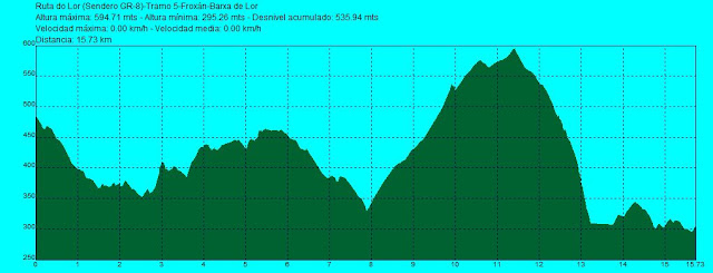
GR-8 (RUTA DO LOR)
SECTION 5: BARX OF LOR-AUGASMESTAS (O Courel)
Distance: 13.5 km
Duration of tour: 3 hours 30 minutes Difficulty
: Easy
Route description:
With this fifth installment of 68 km completed the impressive long distance footpath GR-8, do Lor-Path running through the crossing Courel saw many different places and attractions.
This route runs mostly through the town of Quiroga, through both open and wooded areas and visiting many villages in the region, finishing the same in the town of Augasmestas, Lor riverside, where the resort and the former premises of the Provincial catamarans.
begin our walk in the town of Barxa Lor, with good examples of traditional local architecture, the church and the medieval bridge Barxa, elements that give charm to the small village, for which the pilgrims pass also used the so-called "Camino de Winter." Cross the medieval bridge and began to climb between the houses for a number of sections that run through small paved roads with little traffic. Met
the town of Paradela de Lor, passing in front of Mesón do Lor, always near the river, how could it be otherwise in this GR. When you reach a point we turn to the left across the road for the bottom of a tunnel to reach another beautiful village: Casti Lor, situated in a pleasant valley.
From here the road runs through an area of \u200b\u200briparian forest, up the road national cross again for another tunnel. The road begins a steep climb for a good track to reach the town of San Pedro de Lor, a pretty village sparsely populated, from which have beautiful views of the valley in this part of Quiroga. After the village, we have another stretch of pavement near the railway line, which eventually cross a new tunnel, leaving the road and across the other side, following the course of Lor. We continue by road to reach a new village: Margaride, where you should stop and cool off at its source. We left the village
right and reached the remains of what were Roman gold mines that were exploited in this area, with several tunnels the rock. Now follow a trail that is introduced in forest riparian zone, reaching the river and beginning to climb through pine and chestnut trees above the road. We climb up closer to the railroad we're giving away too over the top. In this section we look beautiful mountain views and a number of geological folds.
For this path carved into the hillside As we finally reached Covas, pretty village situated on a hill, from which we see and Lor Augasmestas and the river in one of his legs wider. Descend by road and we went to see the church of Augasmestas, in a great state of neglect, and finally reached Augasmestas Tourist Complex, also half-abandoned, where the old pier of the catamarans of the Provincial Government.
Here's where Lor River converge in the Sil and where the path ends and the great GR-8 that crosses from one end to the mountains of Courel. This should stop and enjoy the beautiful scenery, starting here named "Sil canyon" one of the landmarks of the Ribeira Sacra.
ROUTE MAP
PROFILE OF THE ROUTE

ROUTE PHOTOS
DRAFT 29 JANUARY 2011 GR-8 (RUTA DO LOR)
SECTION 4: FROXÁN-BARX OF LOR (O Courel)
Distance: 13.8 km
Duration of tour: 4 hours
Difficulty: Easy-Media
Route description:
The fourth installment of the long distance footpath GR-8, called Route Lor do is a very beautiful and spectacular route that runs around the town of Folgoso and Pobra do Brollón, which highlights its beautiful and varied landscapes and ethnographic elements that we observe throughout the entire route.
is a very attractive route that runs parallel to the river Lor and in which we can enjoy diversity of forests, among which is the great souto of Paramedela, a protected area included within the Natura and declared a Site of Community, viewpoints fascinating as the two Pontós Miradoiro das Penas; diverse as ethnographic elements of Froxán Cabanas, the remains of the impressive Barxa Forge and several albariza and Sequeira.
Finally, along the route Froxán visit various villages and the place of As Laceiras, Barxa and Barxa Lor.
started route in the town of Froxán, one of the most attractive and authentic villages showcase Courel, which is partially restored and well-preserved traditional buildings. Here is arranged facades and roofs, and flooring are sanearon the streets, keeping the same type which was used for centuries in the region with houses piled one another, narrow streets, air passages made of chestnut wood beams, balconies with wooden bars. Even began operating a tavern (which unfortunately was burnt in the fire) and a farmhouse. All this, together with the environment in which Froxán located in the middle of a beautiful chestnut souto and abundance of oaks also helped to make this village one of the most unique and visited the mountain. Leaving
Froxán and began to walk the road to Castro Portela, to turn in followed by a trail near the river Lor. From this point the road continues along a beautiful road that runs parallel to the river Lor, which gives us here a great extent. Then begins to climb almost a spectacular path carved into the slope from which we get beautiful views of the vast forests that cover everything before our eyes. It is the great legacy of Courel, as I said Uxío Novoneyra "foi toujours eiquí forest."
continue up the slope through the so-called "Sentences do Parliament", an authentic natural viewpoint to end in a wide track that leads us into the town of Pobra do Brollón and leads through pine forests to the well known "Souto Paramedela "this biological gem concello within Natura and declared as a Site of Community Interest. The souto has a nice Sequeira prepared for visits to learn this traditional element Courel used to dry the chestnuts.
continue on the track along the river Lor and began a painful heat rise that can be somewhat hard to reach, after a bend in the road, the beautiful two Pontós Miradoiro das Penas, privileged vantage point from which you can see in all its splendor Paramedela souto of the river Lor, and all the surrounding mountains.
After resting a while in this place, we continued on up the track until it joins another detour that leads us to the place of As Laceiras, charming and very rare, with only one resident and is located in a hard place access. In the only house there, which also functions as a rural tourism development has been very successfully managed to combine the natural area surrounding it with a series of traditional-style buildings that make up different environments for life in this beautiful town. After visiting
Laceiras As we descend suddenly looking a stunning very difficult path that descends with nice twists and turns to the river views. Once in the river, follow a trail in the midst of lush riparian vegetation, past a small suspension bridge to reach the remains of the spectacular Barxa Forge, one of the most important factories were in the Courel for iron work.
A little later we reach the interesting Barxa traditional village in the middle of a beautiful souto and practically abandoned, traditional constructions in the area.
From anche here on the road a bit until finally reaching Barxa Lor village, somewhat larger population that retains a beautiful medieval bridge where the road ends.
ROUTE MAP
PROFILE OF THE ROUTE
ROUTE PHOTOS
11 DECEMBER 2010 DRAFT
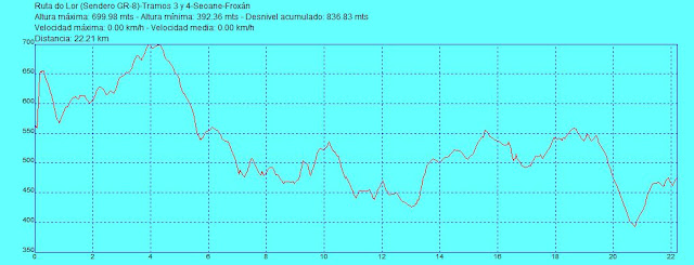
GR-8 (RUTA DO LOR)
SECTION 3: Forge SEOANE-FROXÁN (O Courel)
Distance: 19 km
Duration of tour: 6 hours
Difficulty: Medium
Route description:
This third installment of the long distance footpath GR- 8 is an extraordinary journey that traverses much of the town of Folgoso using the old trails that connected the various towns and villages Courel, offering the traveler a variety of both landscape elements, such as ethnographic and archaeological.
is a beautiful path that runs almost completely parallel to the river Lor, through some of the great Soutar of Courel and contemplating various traditional buildings, and Sequeiros, curtains and ouriceiras. In addition, during the tour will visit numerous villages of the mountains as Abaixo Ferreira, A Pendell, Touzon, Valdomir, A Campa, Vilar and Froxán, passing near the great Castro de Vilar, considered the most important Courel.
Locay We start from the Foundry, one of the major foundries across the south lugués built in 1808 by General Juan Manuel Munarriz artillery during the war of Independence against Napoleon, for the transformation of iron that was extracted Formigueiros Mount. From here we take the old road that connected the two most important towns in Courel: Seoane and Folgoso, and the construction of the paved road all the attention lost, falling into disuse.
The road begins at a souto of chestnut trees and runs along the mountain slope Voucher half. Later we left our right souto spotting Forge Village Vella, a beautiful landscape, overlooking the villages and Sobredo Mercurino.
The path continues beside the spring of Fontaine and within a few meters Roxedaiga crossed the stream, until the first key point of the route: the Pena do Escribano, a spectacular natural view over the river Lor where you can see fantastic views all the villages and mountains around.
A little later we went through the bottom of the remains of the Louseira of Mercurino, one of the oldest stone quarries of Courel. Paradela cross the stream and down towards the village of Ferreira de Abaixo, where is the bar or pontoon "fascinating shop where everything is handcrafted wood and local materials.
We went to the road to Folgoso, and after 100 meters you will turn right along a path that leads us into the two Pedrouzos souto. Soon we began to see a beautiful picture with the Lor River valley in the background.
cross the stream and continue Cabanelas until you reach Ponte do Porto, near the fort of Fouciños. We arrived at km. 10 and we turn to the right until you reach the Ponte de Traspas first and then to Ponte de SUDRIA, near the village and Touzon. A cross Touzon and Pendell, Lor on the river, until finally entering Valdomir, a town where once there was a forge.
From here we begin the second part of this section we will address some of the most interesting sites and villages and emblematic of the saw. We went along to
catux Inn, which no longer functions as such, along the trail that passes through the beautiful chapel of San Sebastian in the direction of the village of A Campa, located in a beautiful environment surrounded by a large souto, and fully cross. Once outside the village, continue along a path that leads along the hillside with a beautiful landscape with river and opposite Lor village Vilamor, always recognizable by its large church that excels at all points.
continue to enter the area known as Os Calangros, spectacular setting and consists of a narrow path carved into the mountain passes through a gorge with the river at the bottom and a stretch is very spectacular.
Once this area and after crossing some stream, enter the known and beautiful traditional village of Vilar, located in a beautiful spot surrounded by an impressive souto of chestnut trees. Has the famous "Fonte da Saúde", with a small ethnographic museum created some years ago by the neighbor Juan Sanchez Rodriguez, known as "Xan do Ferreiro", showing a variety of utensils that have been part of traditional domestic life the mountain villages, as well as tools and implements.
went through the village and we pass the restored "Campo da Feira" to follow the path that goes first to the hermitage of San Roque and then the stunning vantage point where the "Castro de Vilar", considered the best preserved the Courel. The fort is situated on a high to 547 feet high surrounded by a meander Lor formed by the river, and retains a number of Iron Age houses and much of its defensive walls.
After relaxing a bit at this wonderful place, go back and down along the old path through the piñeiral of Abra river reaches and crosses the bridge do Vao, recently refurbished. At this point we typically Mediterranean vegetation invades the microclimate in the area, with strawberry, oak, cork, etc., Crossing the forest known as Froxán sobreiral of "up to the famous village of the same name.
Froxán is one of the most attractive villages existing in O Courel. Is still in the process of restoration and retains its appearance fully genuine traditional construction with typical runners and wooden balconies that rise above cobbled streets and squares. This village is celebrated the first Sunday in December the "Festa da da Pisa chestnut", which retrieves a traditional practice of preparing this fruit. The village has a beautiful square in the center of town, a "campo da feira" with a small recreation area, and the known "Fonte dos Milagres.
ROUTE MAP
PROFILE OF THE ROUTE
ROUTE PHOTOS
13 NOVEMBER 2010 DRAFT
GR -8 (RUTA DO LOR)
SECTION 2 SEOANE Santalla-Forge (O Courel)
Distance: 10.8 km
Duration of tour: 3 hours
Difficulty: Easy
Route description:
This second stage of long distance walking route GR-8, like the first, is a comfortable ride that runs almost always falling on old roads and trails through some of the great forest that holds this nature as souto of Mostad, always near the great river Lor.
We start Santalla main square, next to the source, where we continue a stretch of road until you reach the small village of Traber, with great charm.
From here we start walking along a trail leading down to the river hospitalized for areas with large diversity of vegetation and trees up to "Ponte do Fedo", the first reference point across the rego for Moreira, a tributary of Lor.
The road continues near the river, may be somewhat difficult depending on time of year when transiting in the amount of existing vegetation and the rapid growth of the same. We arrived at "Ponte das Mestas' other bridges in the area that is half fallen, and we cross to follow the river course. Somewhat later cross a third bridge, very nice and totally traditional wood.
The trail continues through beautiful forests up to an area where some huts began to appear: they are the "Cabanas de Paparone, formerly used for keeping cattle, tools or chestnuts.
began to rise smoothly to a very clear crossing in which we will turn to the right towards the Courel campsite. At this point we entered the great souto of Mostad, we cross a narrow path. We headed for the river to link up with a good road that runs along a stretch that leads below the road in front of the campsite of Courel.
continue to the entrance where it follows the same route to reach the church of Esperante, the seventeenth century, situated in a beautiful setting that encourages relaxation and meditation.
After resting in this beautiful place, went up the road that leads to the Esperante village, situated on the slopes of the Serra das Travesas. We crossed it and continued the road that leads to an impressive souto. From this point the road becomes a path, sometimes very little patent, which leads us up the side of the mountain, reaching back to the road that will lead to few meters Nova Forge, where is the Forge Locay, one of the most impressive factories that existed in the Courel which transforms the iron that was extracted from the Monte Formigueiros and where it ends the second section of the GR-8.
Locay The forge is now restored but is not allowed to visit. It is a stunning example of folk architecture and one of the largest steel factories throughout southern lugués, especially height of Banza, about 10 m in height. It was built in 1808 by General Juan Manuel Munarriz artillery during the war of Independence against Napoleon, for the transformation of iron that was extracted Formigueiros Mount, using energy as a source of strong currents of water from the Rio Lor. Later, in 1910, a neighbor arrived from Cuba, became a mill, mill and power plant providing electricity to all Courel.
ROUTE MAP
PROFILE OF THE ROUTE

ROUTE PHOTOS
DRAFT 16 OCTOBER 2010 GR-8 (RUTA DO LOR)
SECTION 1: Cebreiro-Santalla (O Courel)
Distance: 11 km
Duration of tour: 3 hours
Difficulty: Easy
Route description:
With this first installment began the project consists of exploring the impressive trail grand tour GR-8, also known as "Route Lor do" and that over of 68 km will take us across the Sierra do Courel, alongside the flagship channel of the Lor River, visiting villages and seeing many great diversity of elements which are traditional buildings, archaeological sites, monuments and large number of varied forest vegetation.
This first route is a comfortable route that runs mostly falling on old roads and trails and crosses by very attractive with beautiful scenery, traditional villages, many and varied ethnographic elements forests.
The route starts at Cebreiro, using the same route of the Camino de Santiago. Then we enter the forest area where peace and quiet is the dominant note. We
the place called "Fonte do Rei", which marks the limits of the parish of Liñares Celeiro the place where the road divides and separates the Camino de Santiago earlier, continuing along a mountain trail through undefined begins to descend gradually.
continue down path of divisiveness beautiful views of the mountains, overlooking the valley full of vegetation and all kinds of trees. We passed near the village of bitterness and we Celeirós, located in a beautiful location amidst a chestnut souto. We left the village and continue until you reach one of the landmarks along the route: "I Corgos do Flax ", traditional construction consisting of small ponds with continuous input and output of water where they" cooked "the linen for 40 days and then dried and subsequently treated so that it can weave.
continue descending along the mountain of Vieira to reach the site of Fonte do Cubo, where one house, the house of Roque. Nearby lies the source of the river Lor, it's worth visiting.
A little later we passed the village of Fonteboa until it joins the road which leads us to another village without loss of the area: Fonlor. Here we will turn down a path that crosses the river a few minutes and leads Lor another of the key points of the route: the "Muíño of Pedrodaira" interesting well-preserved traditional building built in 1923 and that served many of the villages in the area, which includes, in addition to the construction , an annex to house the horses and carts and had brought the grain flour.
From here the road begins to climb gently to pass near the hill fort Santalla, which has not yet been excavated. Met one of the villages in the area: I Casares, we go through to follow a path that, now, the river drops sharply to introducing us to an area with lots of beautiful forests and vegetation.
From the river we began the hardest part of the route with a steep climb that leads directly to the square of the village of Santalla, where there is a good fresh supply waiting for us, and that is the end of this first tranche of GR-8.
the afternoon, we made a short trip of 3 km away to find the remains of the fascinating Doncos Tower, one of the 3 fortresses that guarded the entrance to Galicia from Leon, built in the fifteenth century and was owned the Valcárcel, one of the most influential bloodlines of that time in Spain.
ROUTE MAP
PROFILE OF THE ROUTE

ROUTE PHOTOS